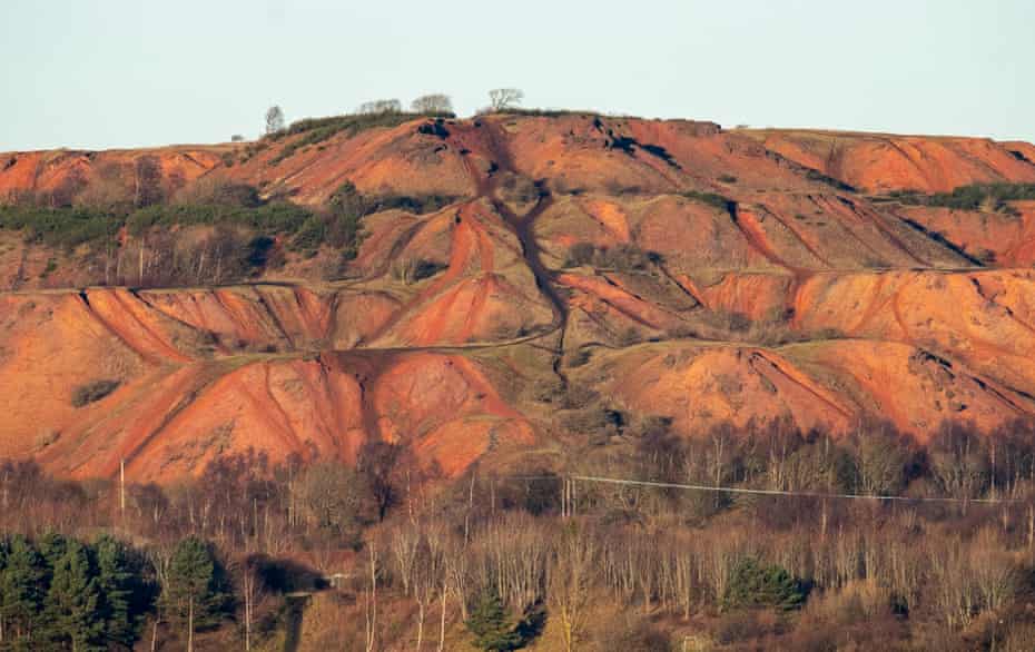
Fifteen miles south-west of Edinburgh, a knuckled red fist rises from a soft green landscape: five peaks of rose-gold gravel stand bound together by grass and moss, like a Martian mountain range or earthworks on the grandest of scales. They are spoil heaps.
Each peak rises along a sharp ridge from the same point on the ground, fanning outwards, in geometric simplicity. Along these ridges, tracks once bore carriages aloft, carrying tons of steaming, shattered rock: discards from the early days of the modern oil industry.
For around six decades from the 1860s, Scotland was the world’s leading oil producer, thanks to an innovative new method of distillation which transformed oil shale into fuel. These strange peaks stand in monument to those years, when 120 works belched and roared, wrestling 600,000 barrels of oil a year from the ground in what had been, shortly before, a sleepy, agricultural region.
The process was costly and effortful, however. To extract the oil, the shale had to be shattered and superheated. And it produced huge quantities of waste: for every 10 barrels of oil, six tons of spent shale would be produced. In total, 200m tons of the stuff – and it had to go somewhere. Hence these enormous slag heaps. Twenty-seven of them in all, of which 19 survive.
But to call them slag heaps is to understate their size, their stature, their constant presence in the landscape; unnatural both in form and scale. Locally, they are called “bings” – from the Old Norse, bingr, a heap, a tip, a bin.

This particular formation, the five-pronged pyramid, is known as the Five Sisters. Each of the sisters slopes gradually to its highest point, then falls steeply away. They rise from a flat and otherwise rather unremarkable landscape – muddy fields, pylons, hay bales, cattle – to become the most significant landmarks of the region: some pyramidal or square; some organic and lumpen; others still rising raw-flanked and red to plateaux like Uluru.
Oil production continued on a massive scale here, until the Middle East’s vast reserves of liquid oil came into ascendancy. In Scotland, the last shale mine closed in 1962, bringing to an end a local culture and way of life, leaving mining villages without the mines to employ them, and only the massive, brick-red bings as souvenirs. For a long time the bings were disliked: barren wastes that dominated the skyline, fit only to remind the region’s inhabitants of an industry gone bust and an environment pillaged. No one wants to be defined by their spoil heaps. But what to do about them? That wasn’t clear.
A few were levelled. A few later quarried afresh, as the red stone flakes – “blaes” as they are technically known – found a second life as a construction material. But mainly the bings lay abandoned and ignored. After a while, the villages in their shadows grew used to their silent presence. To enjoy them, even.
It’s not hard to find the bings. You can see them from miles off. But the newly launched Shale Trail, makes it easier to plot a route to explore them. The 16-mile walking and cycling trail between West Calder and Winchburgh takes in the sites and communities connected to the shale heritage.

My aunt and uncle live in West Lothian, not far from the Five Sisters and even closer to their larger cousin at Greendykes. Last time we went to visit my relatives, my partner and I took a detour to climb the sleeping giant. The light was flat and silver, the sky grey and cottoned over with cloud. We parked in a semi-derelict industrial estate, between rust-streaked Nissen huts and faded signposts, and wandered out into a landscape of almost unbelievable strangeness, like the first colonists on a new planet.
Deep ponds of bottle green had gathered in hollows at the base of the slope, at the foot of each dell and gully formed by the tip’s puckered edges, their outlines picked out in the acid green of the pond weed and hair-thin grasses that intermingled in the shallows. Water lilies poked their noses through the surface, where tiny insects skated by. Whip-thin birches sprung with unlikely fervour from their gravel beds, silk-skinned and shining and bearing tiny buds of sweet new leaves. We pressed between the birches, along a narrow footpath, to emerge at the base of the bing proper, and found its vast red flanks rising ahead of us, contours and crannies picked out dramatically in vegetation, and striated with tracks.
We began to climb, but the going was difficult. The blaes had solidified into a dense conglomerate to form rock faces in places, in others scree. Elsewhere, the outermost layer was grassed over but crumpled, like laundry, where the skin had slipped down, and when we put our weight on it we post-holed as if through rotten snow. Grit collected in our shoes.

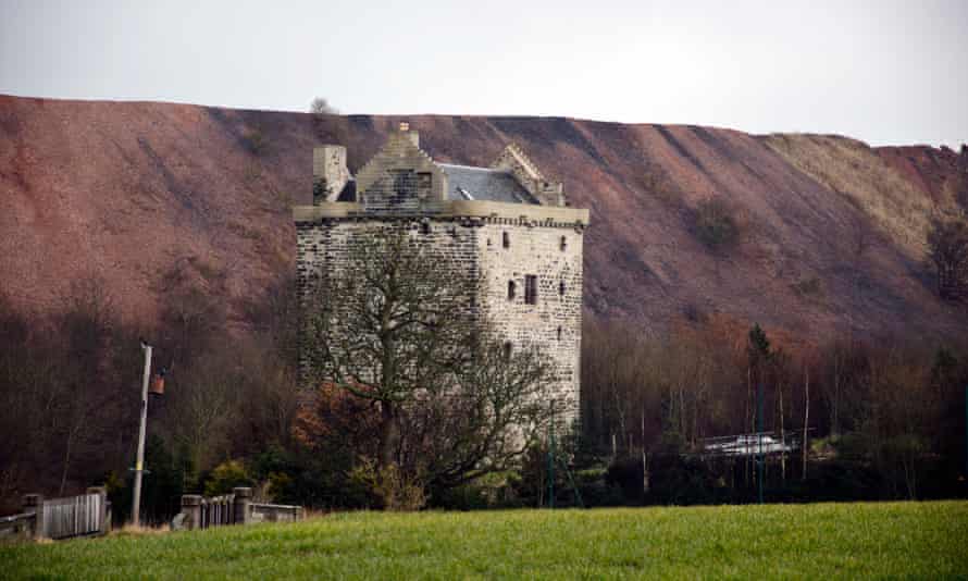
After a fashion, we reached the top – a wind-battered upland that offered panoramic views across clean-swept fields to Niddry Castle, a 16th-century tower, behind which yet another bing – a sheer cliff of spent blaes, ruddy-faced but streaked with green and grey – stood breathing down its neck. And beyond, yet more, rising proud from the flats.
The flora here was a strange mix; it was hard to get a fix on the sort of climate we found ourselves in. Russet shoots of willowherb were coming up across the tops, as they might along any roadside in the country. But other than that, the vegetation had a sparse, sub-Arctic feel: a close crop of soft-furred leaves and starred flowers and short, blond grass. But there was red clover too, with their sweet heads full of nectar just beginning to open, and spotted orchids. The year’s first bumblebees blundered by, revving their engines. Buds and shoots were snaking up, out of the gravel. The land basking, warming, ready to bloom. It was the end of April. Impossible not to think of TS Eliot:
breeding
Lilacs out of the dead land, mixing
Memory and desire, stirring
Dull roots with spring rain.

Back in 2004, the ecologist Barbra Harvie made a survey of the bings’ flora and fauna and found to almost everyone’s surprise that, while no one had been looking, they had transformed into unlikely hotspots for wildlife. “Island refugia” she termed them: little islands of wildness in a landscape dominated by agriculture and urban development.
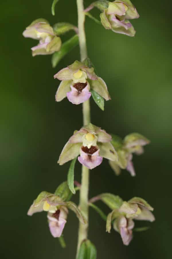
Hares and badgers, red grouse, skylarks, ringlet butterflies and elephant hawkmoths, 10-spotted ladybirds. Among the flora was a diverse array of orchids: the vanishingly rare Young’s helleborine, a delicate, many-headed flower in pale greens and pinks, found in only a handful of British locations; the early purple orchid in ragged mauve; the greater butterfly orchid, with its winged petals – and a genetically distinct birch woodland that had established naturally at the base of the tiny bing at Mid Breich.
Overall, Harvie recorded more than 350 plant species on the bings – more than can be found on Ben Nevis – including eight nationally rare species of moss and lichen, among them the exquisite brown shield moss, whose thin tendrils loft targes to the sky like an army in miniature. Over the space of a half-century, these once-bare wastelands had somehow, magically, shivered into life.
Eliot’s Waste Land drew from the “perilous forest” of Celtic mythology, a land “barren beyond description” through which a hero must pass to find the Otherworld, or the holy grail. The bings, too, already offer a glimpse of what we might find on the other side: recuperation, reclamation. A self-willed ecosystem is in the process of building new life, of pulling itself bodily from the wreckage. In starting again from scratch, and creating something beautiful.
The bings – and derelict sites like them – offer us an insight into the processes of reparation and adaptation, and – more valuable still – they offer us hope. They remind us that, even in the most desperate of circumstances, all is not yet lost.
This is an edited extract from Islands of Abandoment: Life in the Post-Human Landscape by Cal Flyn (HarperCollins, £16.99). To order a copy for £14.78, visit guardianbookshop.com. Delivery charges may apply


